

April 2022
The Desert is also glimpsed in both the geological category of the fossil insofar as we consider fossils to have once been charged with life, to have lost that life, but as a form of fuel can provide the conditions for a specific form of life—contemporary, hypermodern, informationalized capital—and a new form of mass death and utter extinction; and in the calls for a capital or technological fix to anthropogenic climate change.
Travelling through the coastal regions of Kutch in 2021-2022, I encounter the intertidal and littoral environments of Kutch as inhabited spaces with material histories of occupation. In mainstream accounts, these regions are often referred to as wasteland, as submerged lands, as marginal—words that indicate a lack of human use and value. But these amphibious geographies have been inhabited for centuries by the fishing community and the pastoral Fakirani jat communities who traditionally graze camels on the coast. Their presence in these regions is evident in their livelihood practices, in their skills of navigating the mudflats, and in the shrines on islands and sand dunes across the coast.
Today, Kutch’s coasts are becoming a site of intensifying capitalist extraction and production—a new economic frontier for state and capital.[1] It is driven by state-facilitated infrastructural development projects that require the destruction of natural resources and state and market-based policies of protection and conservation in context of climate change. As my ongoing fieldwork indicates, destruction and protection operate parallel to one another, perceiving and mapping the ground in different and contradictory ways.![]()
Figure 1. Screenshot of mangrove assessment by remote sensing (source: Landsat data, 2011-2017).
My work attends to how the materiality of the ground impacts life-worlds and is made possible by people from the fishing and pastoral communities of Kutch, as well as friends, researchers, and NGO and cultural workers. Attending to the ground’s materiality has meant an encounter with characters that are fictional, archaeological, human, or ecological and a corresponding experimentation with non-academic forms of writing. In this exploratory essay, I describe one such encounter with inland mangroves of the Guneri Village in the Lakhpat area of Kutch.[2] This essay began with my interest in markings I noticed on the mangroves, which distinguished them as ‘dead’ or ‘alive’. Rather than framing the inland mangroves as an exception in the landscape,[3] I think of them as lively bodies that have resonances and that inhabit a relational ground. Representing memories of the sea materially, I ask whether such representations might help us think through new imaginaries of world building.
The mangroves are both material and memory
We drove from Bhuj the unofficial capital of the region of Kutch to Lakhpat tehsil (administrative area) on India’s border with Pakistan. There are two highways that connect Bhuj to the Lakhpat. The primary traffic along the inland route consists of trucks carrying limestone or lignite. Both sedimentary rocks, they hint at the geological history of the ground here and its oceanic pasts. If you travel around 5 pm in the evening, you see the buffalos’ crossing paths that cut across their grazing grounds.
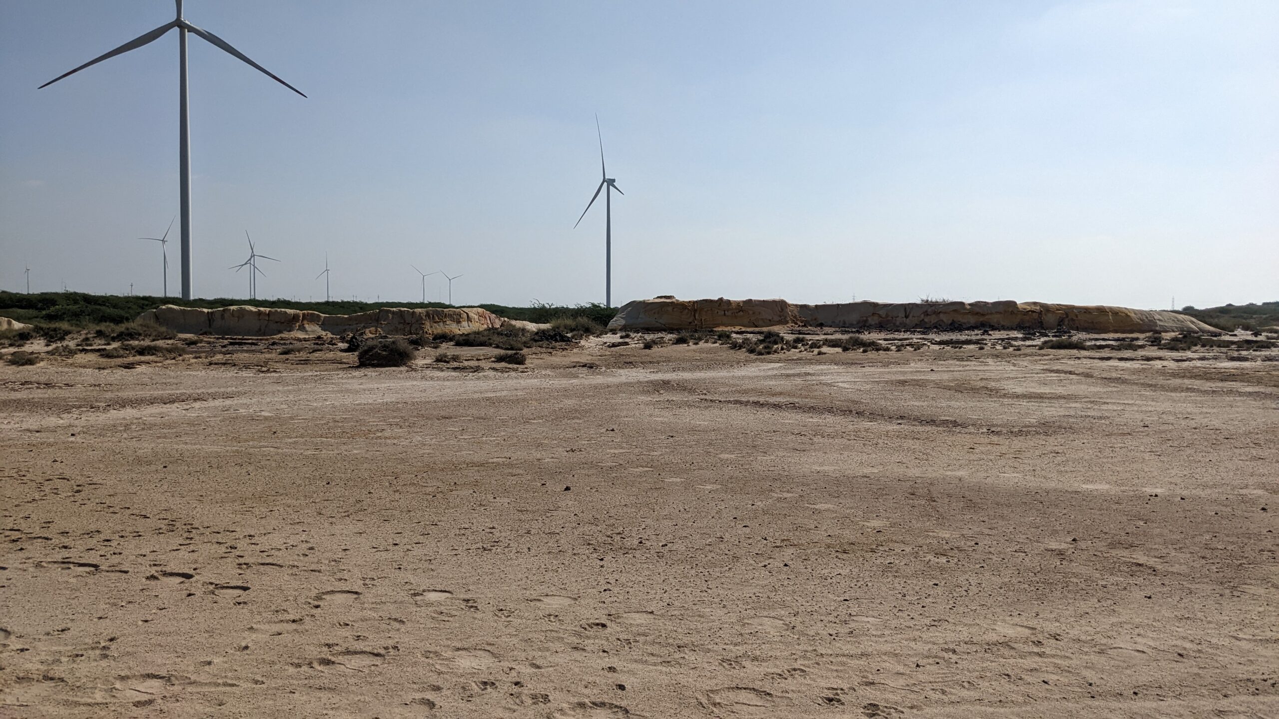
Figure 2. Walking to the mangroves, Deva bha identified tracks of hare, porcupine, chinkara, nilgai and foxes (photograph: Rai).
We pick up Deva bha from Dayapar, the main centre of the tehsil. Dayapar is no longer a village, but not yet a city. Deva bha is from the nearby Guneri, a village of grazers and agriculturalists who do primarily rain fed agriculture.[4] He is taking us to see inland mangroves of his village. We exit the highway, bumping through pasture and open land over small shrubs, rocks and grass, patches of peanut fields (a cash crop now common to Kutch). We follow tractor tracks until the car can go no further and then walk for about two kilometres. The land is gently undulating, covered with grass of different varieties. The landscape is yellow, mustard, olive green and brown. We are crossing a forest—a small one though, barely ankle-high. Rains have made the soil muddy in places. The wind whistles through the flat landscape. In the distance I can see an army of windmills marching through the land, now a common site in Kutch. Save for Deva bha, we have no idea of direction or landmarks. I drop a GPS pin to locate myself later. We pass by a small herd of chinkara: Indian Gazelle- dainty deer with stripes on their faces and extremely curious eyes. Chinkara are native to Iran, Afghanistan, Pakistan, and India. They sketch contiguous geographies now divided by national borders. They remind me of the shared origins of our lands. Chinkara can go without water for days and derive moisture from plants. Their habits reflect the regions they inhabit, where water is precious and found in many different forms.
I have been reading about the inland mangroves that we came here to see, but nothing quite prepared me for this place. I literally stumbled off a road with trucks, clinker, and coal onto a landscape that only evoked feelings of reverence and wonder. My sonic field consists of a whistling wind, the murmur of grass and bird calls in a distance. The world rustles. We pass by a flat sided rock with swirls of red and yellow–ancient paintings by tectonic forces and earth minerals. The rocky land curves up. On a small mound is a stretch of forest.
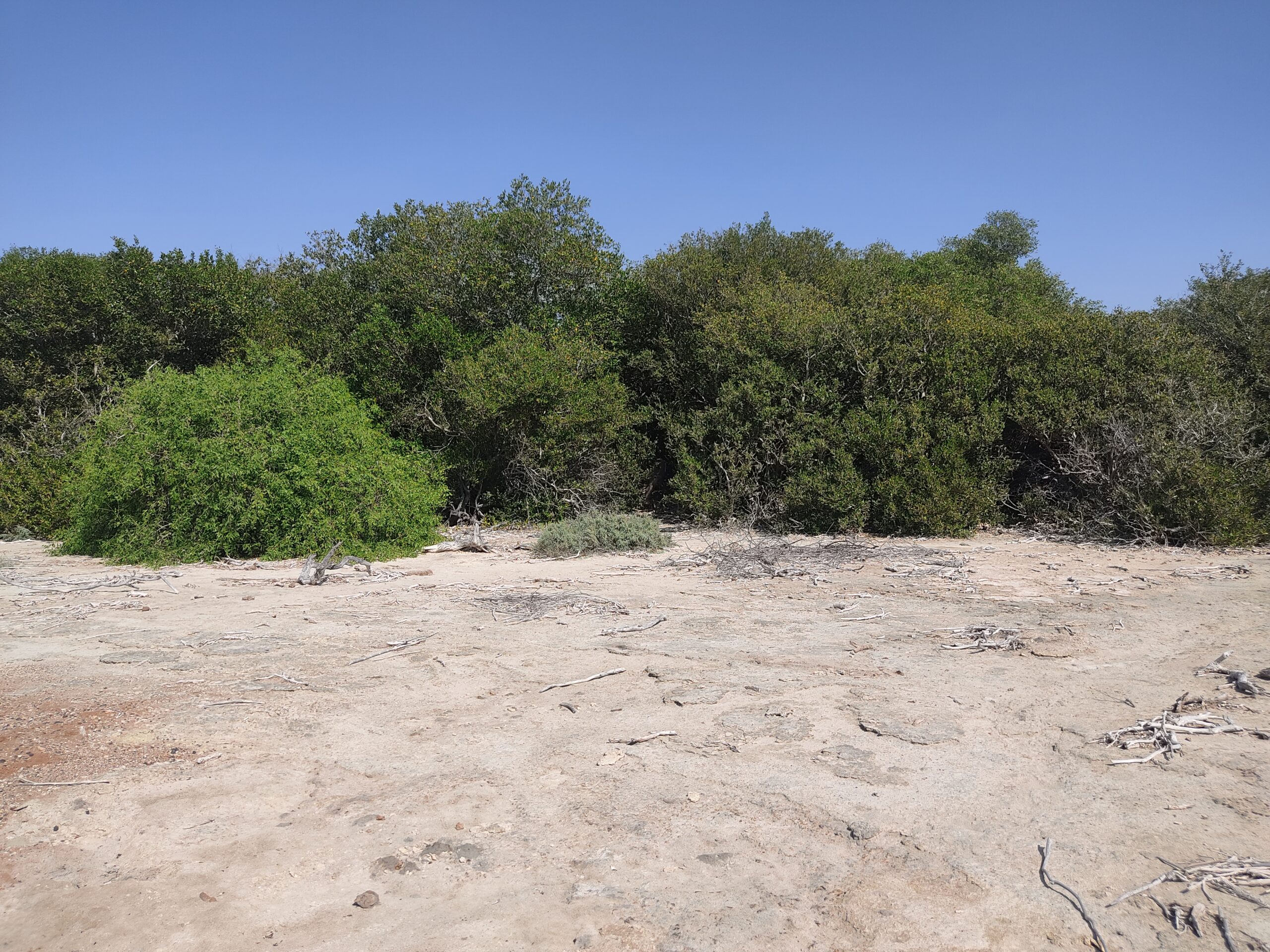
Figure 3. It is believed that a pir (saint) planted a stick at this site near the Indus Delta where the mangroves are located today. The sea probably receded from here during the 1819 earthquake (photograph: Rai).
It’s curious and a bit unbelievable that these are mangroves at different life stages—some young and some old. Saplings sprout from a thick, muddy undergrowth sustained by underground streams of salt water and nurtured by the villagers who consider them sacred. Deva bha says that they have for generations been in the villagers’ care. This care includes established practices: cutting is discouraged and plucking leaves for fodder is only encouraged during droughts that take place at regular intervals. The landscape is also one of use: buffaloes, sheep, goat, and camels graze on the surrounding saline grasses and plants. Deva bha identifies the different grasses, shrubs and berries that grow in this saline ground—chund, lana, chabbar, desi jhad, choonth, pelu—species I have so far seen only in coastal areas.
The mangroves of Guneri are of a species called Avicennia Marina named after Abdallah Ibn Sina (980-1037 AD), a Persian philosopher, physician and polymath who was the first one to write about this plant’s lifecycle. One of the 8 species classified under the genus Avicennia, they live in intertidal zones of estuaries and seabeds, thriving in extreme saline conditions as well as inundations of freshwater.[5] These plants are also known as white or grey mangrove because of salt crystals that accumulate in their roots. The accumulation is possible because of the root structure of these plants that grow upwards through the soil and the leaves that perspire the extra salt. This trait of adaptation to saline conditions is prominent in scientific literature on Kutch across various disciplines. Along with people and plants, the cattle in Kutch have also adapted to salinity: cows, buffaloes, camels, goats all feed on a continuum of saline to sweet grass.
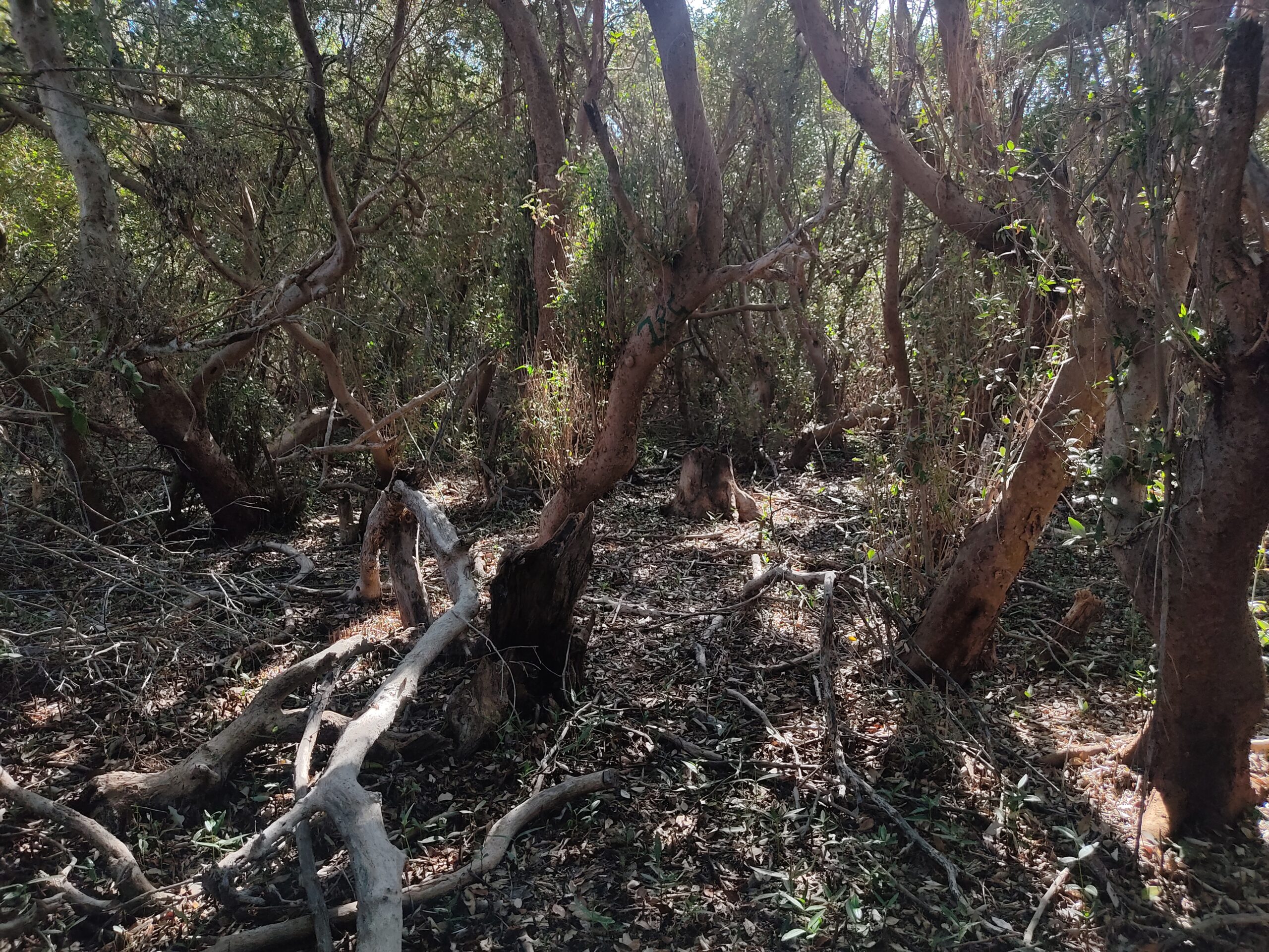
Figure 4. Muddy undergrowth (author’s photograph).
What does it mean to touch or grasp memory? Visual anthropologist and filmmaker David Macdougall writes that the depiction of memory draws upon a repertoire of signs, including those of survival.[6] These can be images of objects that have a physical link to the remembered past. The mangroves here are constitute physical past—lively fossils that materially carry with them a memory of the sea. Fed by subterranean streams of salt water, they are an ecosystem that has survived. Their liveliness gives them a unique quality that helps us think through our own conceptions of the inert and the lively. It’s a bit like discovering a dinosaur, bringing with it the conundrum of what one does with the it.
Accordingly, efforts to classify the mangroves as a Biodiversity Heritage Site (BHS) are underway. The identification and categorisation of a BHS is part of a complex process that stretches from the global to the local and centres itself on the conservation, rightful use and protection of the biological as data. The Convention on Biological Diversity was drafted at the UNCED Earth Summit in Rio de Janeiro in June 1992. It came into force in December 1993 and India became a signatory in 1994. India’s Biological Diversity Act (BDA) was passed in 2002, leading to a national biodiversity authority that oversees its implementation and activities. State Biodiversity Boards (SBB) and village-level Biodiversity Management Committees (BMC) were created under the Act to implement and operationalise it at these levels.[7] The idea of biological heritage is also complex because it cuts across spatial and temporal scales—the geological, historical, and ecological—all governed through different policy and legal regimes, and actors on the ground. The latter in this case includes the forest department, local conservation organisations, and the biodiversity committees at state and central levels. With the support of organisations such as GUIDE and Sahjeevan, a village-level BMC was put in place, a People’s Biodiversity Register was created in consultation with the villagers, and a proposal is currently pending since 2014-2015 with the state diversity board to designate the area as a BHS.[8]
Declaring the inland mangroves as a heritage site is a political strategy in a context where land and natural resources are rapidly being acquired for industrial, logistical and mining. The BHS designation marks the mangroves and their environs as a legal exception to the extractive and industrial capitalist norm that locally manifests in a language of economic growth, development, and progress. It indicates that this specific stretch of land, approximately 5 -6 acres in all, has a specific value that is biological, historical, and cultural.[9]
Degrees of liveliness
During our visit to the mangroves, the trees were marked with green numbers or in red by the forest department. The red marked the dead trees and the green those alive. The marks illustrate the fundamentally different schemas that were operating simultaneously—different forms of calculation and different approaches to the mangroves. While the community wasn’t clear whether the Forest department or the local conservation organisations had marked the trees, a forest department representative told me that they paint and count the trees to better protect and regulate them by keeping track of each tree individually.
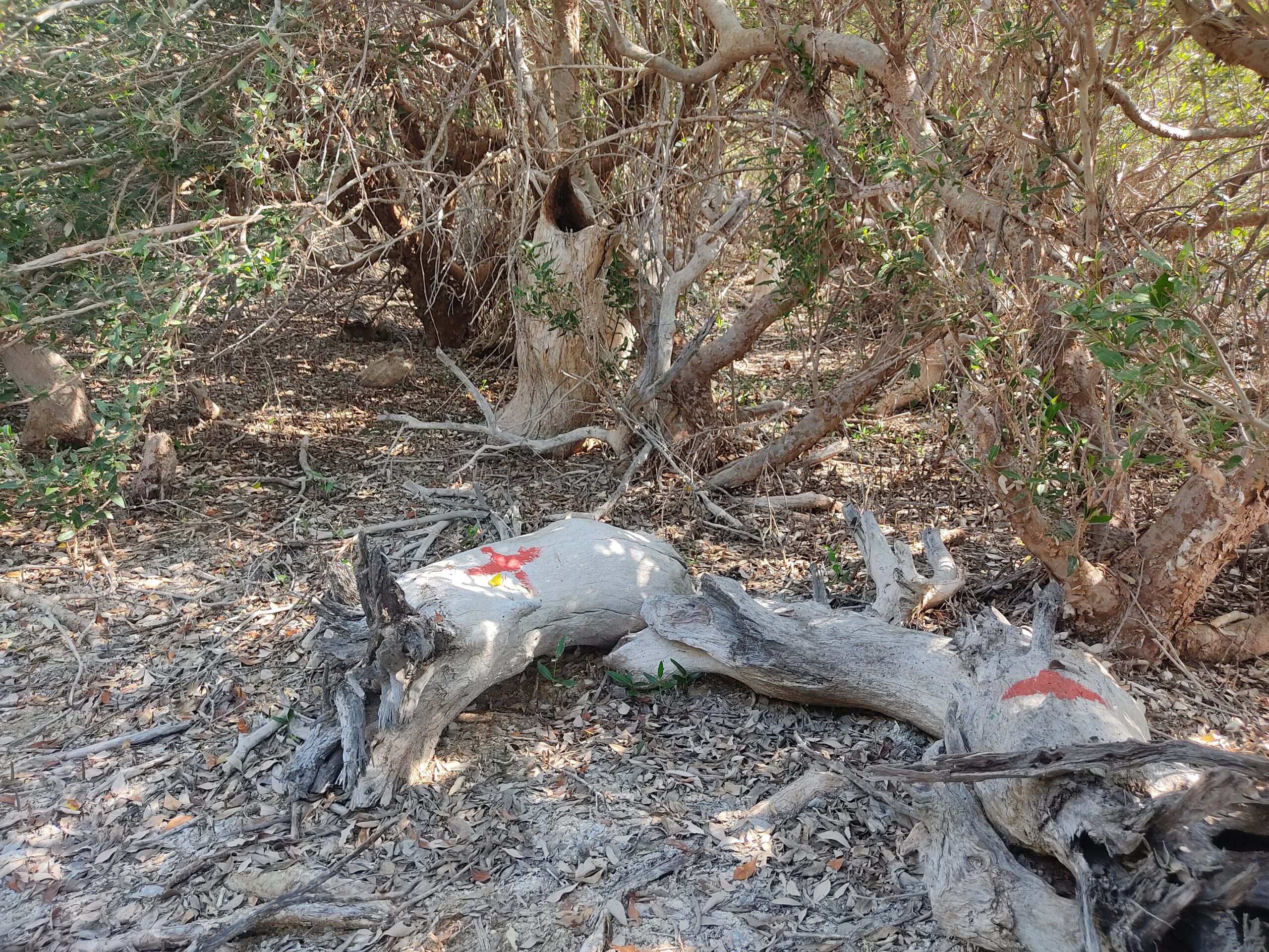
Figure 5. Markings by the forest department (photograph: Rai).
When the trees are marked as dead, it representationally removes them and their trunks from an organic cycle of life and death, a regenerative cycle that also includes various other microorganisms, plants, insects, animals, and birds living here. These representations gradually become reality due to the parameters and practices involved in conservation. For example, one of the initial suggestions made during a meeting of the BHS process was to fence off the mangroves. The suggestion was rejected by the villagers on grounds that it would harm the animals and organisms that also live in the area. The fence materialises human use, indicating where we see value in the ground and creating an inside and an outside within what ought to be a shared landscape.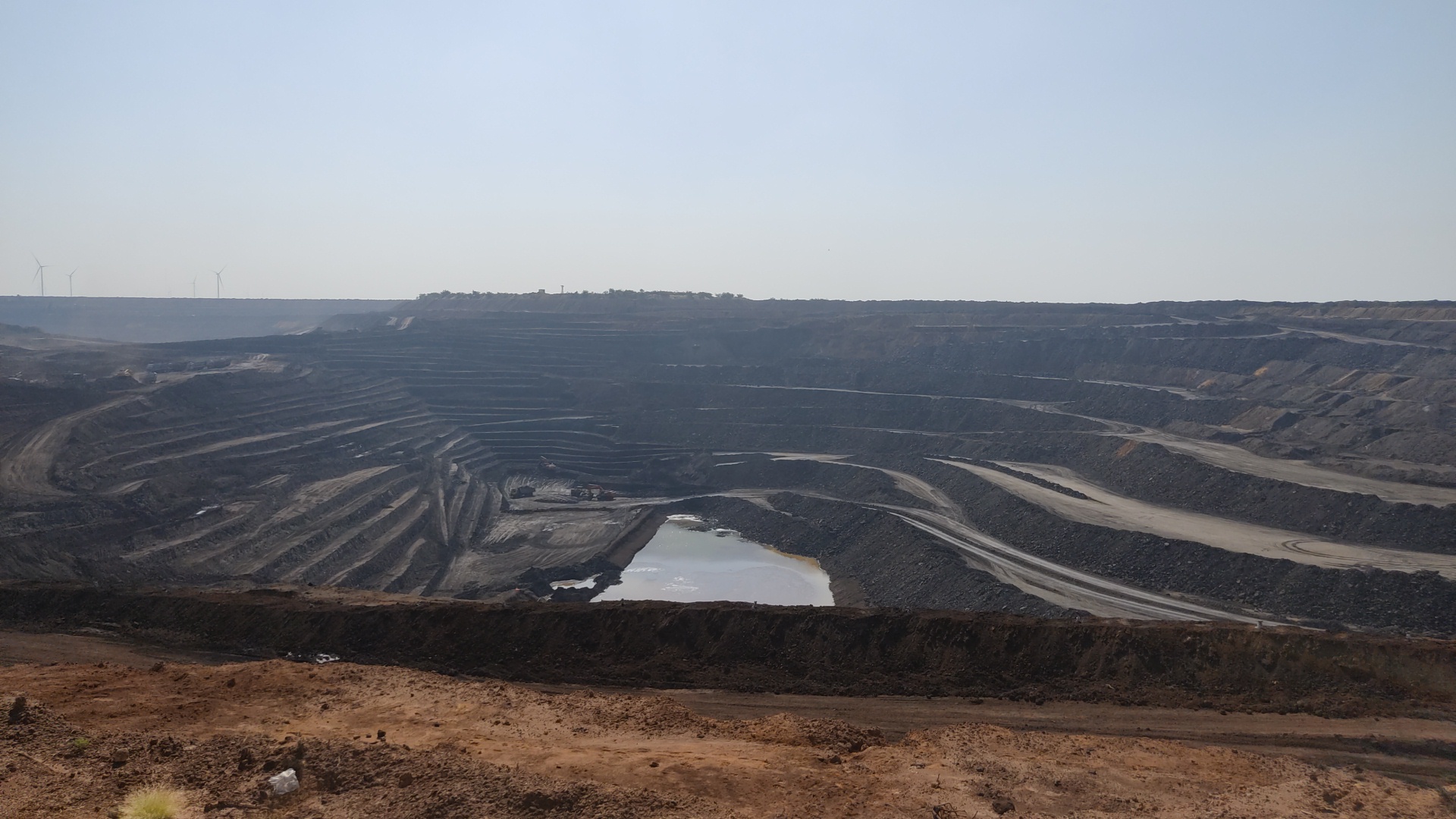
Figure 6. Umarsar Lignite mines, Gujarat Mineral Development Corporation (author’s photograph).
Much of these practices are governed by the logics of conservation and sustainable development, as the BHS tag also illustrates. But both refashion nonhuman life as a resource for human use.[10] Rather than navigating away to a larger scale that the question of biodiversity and heritage can indicate, which risks ‘reinstating a universal human objective observer’.[11] I want to navigate back to the particularity of Guneri. Following the ground reveals the scales, logics and operations of extraction. It also helps delve deeper into a comparative politics that extraction embodies. Elizabeth Povinelli: “Industrial capital depends on and, along with states, vigorously polices the separations between forms of existence so that certain kinds of existents can be subjected to different kinds of extractions” (italics mine). To stay with the ground is to account for the lignite and limestone mining taking place in a radius of 15 kilometres from the inland mangroves. I want to underscore that the mangroves are kin to the lignite and limestone being mined, as both are products of an oceanic past. The mangroves are treated as worth protecting, an exception, relative to the fossils that are limestone and lignite. Both are assigned a graded value according to human need and perception. While extractive capitalism demands the mining of lignite and limestone for cement to fulfil short term energy needs (as a mining engineer told me), it needs the mangroves to stay in the ground for a different kind of extraction—as a local solution to the global climate crisis. While the nature of local and legal entanglements is complex in the case of the Guneri mangroves (for example, it’s unclear, even to those involved in the process, how these mangroves will be ‘governed’ in the future), its recognition as unique has already brought along a technical and legal discourse. Authority is made to rest with experts and policymakers, instead of the community that has cared for the mangroves, while they remain resolute that the mangroves are under their care, not authority. Indeed, in 2021, an amendment to the BDA Act was debated, which removes reference to the preservation of habitats and changes guidelines on benefit sharing with local communities in certain cases. While the BMC then enables the villagers to claim authority, the change in the central act might potentially undercut this.
The slow extraction of the mangrove from its relational landscape transforms it into an object that can be plugged into different scales of world-making.[12] Removing the mangrove from its world, even as a representational act, can be a slower form of violence that dispossesses both human and non-human life. It has parallels to mining that values the ground only as a coal or limestone depository[13]—as material, not memory. Protection and destruction operate entwined.
Do bodies have resonance?
Talking to Deva bha and later others, indicates that relationality exists in multiple ways. The mangroves exist as part of a landscape that is determined by the quality of the subterranean ground. The saturation of salt on the surface of the ground that you see near the mangroves gives the ground a depth that impacts surface lives and economies. It sustains mangroves as well as other forms of life. It sustains patterns of grazing and livelihoods that rely on a close encounter with the ground—a ground that is shared between the different characters that inhabit these landscapes with varying degrees of liveliness, ranging from sedimentary rocks that create lignite and limestone to lively mangroves.
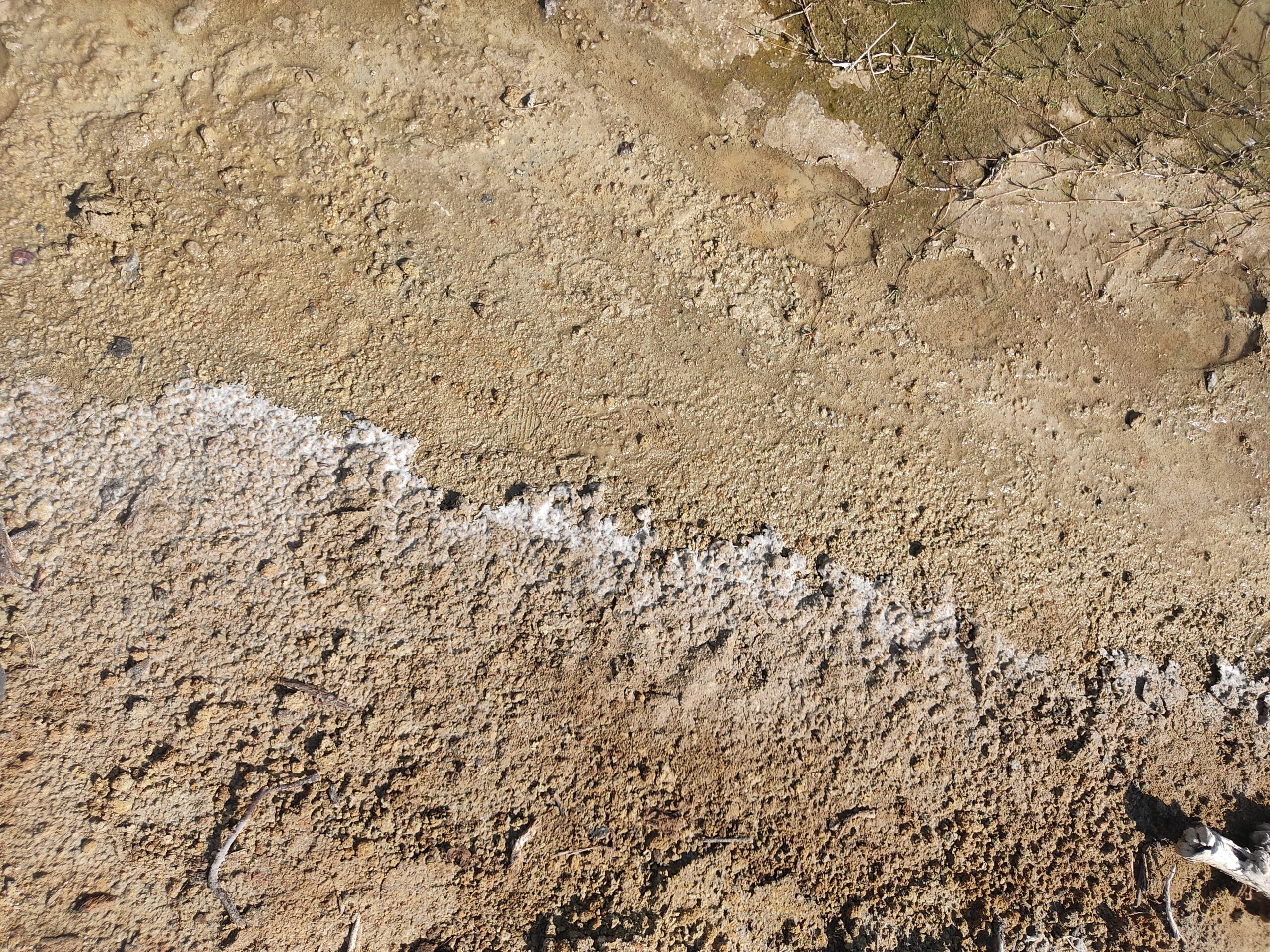 Figure 7. Salt encrustation near the mangroves (author’s photograph).
A recent talk by movement practitioner and dancer Navtej Johar resonates with the question that my encounter with the mangroves has left me with: could we think with the mangrove as a lively body? Johar and I spoke of how bodily interaction and resonance in space cuts across species and degrees of animation. The space evokes wonder because of this interaction and resonance—the mangrove lives still in relation to the past sea but is sustained by the different plants, organisms, birds, and animals that live with, in and around it. It exists in relation to the village of Guneri, where both are tied together and sustained within existing cultural and material practices. The human and the non-human exist in relation to practices of use and the sacred in a sustaining, rather than extractive, relationship, offering different imaginaries of world-building. These resonances and interactions in turn give the mangrove its shape.
Notes
[1] Shilpi Srivastava and Layla Mehta, “The Social Life of Mangroves: Neoliberal Development and Mangrove Conservation in the Changing Landscape of Kutch,” Environment and Planning E: Nature and Space (2021): https://doi.org/10.1177/25148486211045360 [OnlineFirst].
[2] Remains of inland mangroves have also been found at Shravan Kevadiya, another site in Kutch. See Amit Pandey and Arun Kumar Mahatao, “Restoration Potential of Degraded Inland Sacred Forest of Kachchh, Gujarat: An Evidence of Shravan Kavadiya Sacred Grove,” International Journal of Pharma and Bio Sciences 10, no.3 (2019): 171–180.
[3] See the Gujarat Institute of Desert Ecology’s (GUIDE) Annual Report for 2014-2015; Pratiksha Patel and Govindasamy Agoramoorthy, “India’s Rare Inland Mangroves Deserve Protection,” Environmental Science and Technology 46, no.8 (2012): 4261–4262.
[4] While we have a vocabulary and ontology in context of indigenous peoples, in this case, the community is not indigenous, but their relationship to the mangroves and the landscape is based on historical-cultural and ecological traditions.
[5] Hrudayanath Thatoi, Dibyajyoti Samantaray and Swagat Kumar Das, “The genus Avicennia, A Pioneer Group of Dominant Mangrove Plant Species with Potential Medicinal Values: A Review,” Frontiers in Life Science 9, no.4 (2016): 267–291.
[6] David MacDougall, “Films of Memory,” Visual Anthropology Review 8 (1992): 29–37.
[7] The Act requires local authorities to set up a Biodiversity Management Committee for (i) promoting conservation and sustainable use of biodiversity including preservation of habitats, conservation of folk varieties, breeds, land races, and microorganisms, and (ii) documentation of biodiversity.
[6] The inland mangroves of Guneri have been identified for designation as Biodiversity Heritage Sites, with issuance pending (see also: Gujarat Ecology Commission’s 2016 newsletter on Status of Biodiversity of Gujarat State).
[9] A biodiversity survey published in 2017 identified “threatened” species of plants and “extremely rare” species of mammals and wolves here as per the categories used by the International Union for Conservation of Nature.
[10] Stacy Alaimo, “Afterword: Adequate Imaginaries for Anthropocene Seas,” In Irus Braverman and Elizabeth R. Johnson (eds.) Blue legalities: The Life and Laws of the Sea (Durham, NC: Duke University Press, 2020), pp.311–326.
[11] Alaimo, “Afterword,” 320.
[12] For mangroves and carbon trading see Amber Huff, “Frictitious Commodities: Virtuality, Virtue and the Value in the Carbon Economy of Repair,” Environment and Planning E: Nature and Space 0, no.0 (2021): https://doi.org/10.1177/25148486211015056. [OnlineFirst]. See also: Anna Tsing, “The Global Situation,” Cultural Anthropology 15, no.3 (2000): 327–360.
[13] Ayesha Omer, “Coal Ground,” Cultural Studies 35, no.4–5 (2021): 920–945.
Image
Salt encrustation near the mangroves (author’s photograph).
About the author
Ishita Sharma works at the intersection of land, dispossession, territoriality and resistance. She is interested in developing practices based upon feminist methodologies and critical geography. She has worked as a facilitator and researcher with youth and feminist organisations in South Asia. She was a fellow with the Digital Earth Fellowship 2018-2019 and received her M.A in Human Rights Studies from Columbia University, New York. She is currently a PhD candidate with the Topological Atlas project at Technical University of Delft (funded by the European Research Council under the Horizon 2020 research and innovation programme [grant agreement number 758529]).
Cite as
Ishita Sharma. “Extractivism: Memories of the sea,” edited by Eray Çaylı, JVC Magazine, 20 January 2023, https://www.journalofvisualculture.org/extractivism-4/